Oceanic General Circulation (Figure 1)
Figure 1 shows a schematic diagram of the oceanic general circulation as inferred from observations. In the diagram, each ocean is divided into the surface layer (to the depth of roughly 300 m), intermediate layer (300-1500 m), deep layer (1500-4000 m), and bottom layer (4000 m to the bottom). The Atlantic, Pacific, and Indian Oceans are not isolated but interact with each other through the Southern Ocean, which surrounds Antarctica, the Indonesian Archipelago, and the Arctic Sea. The understanding of oceanic general circulation is indispensable for the prediction of long-term climatic variation.
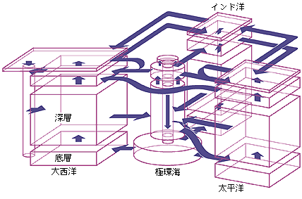
[Figure 1]: A schematic diagram of oceanic general circulation. The arrows indicate water mass transport from one layer to another or from one ocean to another.
Absorption of Anthropogenic Matters by the Ocean (Figure 2)
Figure 2 shows meridional sections of the concentration of anthropogenic CO2, a carbon isotope originating from the nuclear bomb, and Freon 11, reproduced in our oceanic general circulation model. These anthropogenic matters are seen to be carried into deeper layers by vertical convection and spreading along with the flows of the North Atlantic Deep Water, Antarctic Bottom Water, and Antarctic Intermediate Water. This kind of simulation is necessary when the performance of the model is evaluated against observations. Also, estimating how much anthropogenic CO2 is absorbed in the ocean is critical to the prediction of global warming.
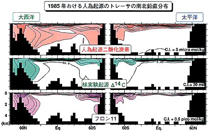
[Figure 2]: Meridional sections of anthropogenic matters, reproduced by the oceanic general circulation model.
Heat Transport by the Ocean and Atmosphere (Figure 3)
Figure 3 shows northward heat transport by the atmosphere and ocean in a coupled atmosphere-ocean general circulation model with an idealized geometry. Two simulations are done, one with an annual mean solar radiation and the other with a seasonal one. The ocean's relative contribution to the total heat transport is larger with seasonality than without.
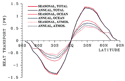
[Figure 3]: Northward heat transports in a coupled atmosphere-ocean general circulation model.
Circulation in the North Pacific Intermediate Layers (Figure 4)
CCSR is studying North Pacific circulation patterns, which are supposed to play an important role in decadal climate variations. Figure 4 compares simulated North Pacific circulation patterns, with and without wind stress, under the same thermal boundary conditions. The flow is along isobars. It is known that a flow driven only by wind stress cannot easily cross the lines shown in the figure. However, there is a southward flow crossing one of the lines along the western boundary both with and without wind. This indicates that the flow crossing the line is a manifestation of a flow system driven by thermal forcing.
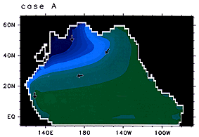
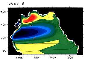
[Figure 4]: Pressure distribution at the depth of 600 m in the North Pacific reproduced by our oceanic general circulation model. Case A, without wind stress; case B, with wind stress. Blue and red indicate high and low pressure, respectively.
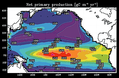
Modeling the Marine Ecosystem (Figure 5)
The marine ecosystem plays a vital role in the biogeochemical cycle, including that of greenhouse gases. The food chain of the ecosystem starts from the primary production of the phytoplankton. It is therefore necessary to estimate the primary production in order to understand the biogeochemical cycle. Figure 5 shows the net primary production reproduced by our oceanic general circulation model coupled with an ecosystem model. The simulated values are in general agreement with observations, except the former is somewhat larger around the center of the equatorial region.