CHAPTER
3 : VULNERABILITY AND ADAPTATION
INTRODUCTION
An assessment of a country's vulnerability
is an evaluation and analysis of the scope and severity of potential impacts
of climate changes on the natural environment, main sectors of the economy,
human health and social activities.
An assessment of a country's adaptation
is an identification and evaluation of changes in technologies, practices,
and policies that can be adopted to prepare for adaptation to climate change
impacts.
It has been widely recognized that small
island states are highly vulnerable to climate change and the resulting
sea-level rise. Adaptation to these changes, on which countries should
mainly focus during the next decade, is one of the environmental challenges
to be taken into consideration for sustainable development. Anticipatory
actions should be taken to mitigate the negative effects of these changes
and priority should be given to the implementation of remedial measures.
One possibility is to integrate climate change in the socio-economic development
and management programmes at government and non-government levels.
In Mauritius, key socio-economic sectors
which inter-alia are most likely to be affected by climate change and sea
level rise are:
-
coastal resources
-
agriculture
-
water resources
-
fisheries
-
health and well-being
-
land use change and forestry and
-
biodiversity
Sectoral impacts are identified and strategies
are proposed to facilitate adaptation. These include revised management
strategies to cope with the environmental stresses, contingency planning,
research and development.
CLIMATE
CHANGE SCENARIOS
Climate change scenarios are designed for
use in identifying sectoral sensitivity to climate change and to show the
potential magnitude of impacts but not to predict future climate.
Three basic options are available for creating
climate change scenarios:
(i) general
circulation models (GCM)
(ii) incremental
(iii) analogue.
Climate Change
Scenarios
General circulation models (GCMs) are mathematical
representations of atmosphere, ocean, and land surface processes. The GCMs
are run for current climate (1 x CO2) and for a doubling of
carbon dioxide content (2 x CO2). Output from four GCMs, namely
the Goddard Institute for Space Sciences (GISS) model, the Geophysical
Fluid Dynamics Laboratory (GFDL) model, the Canadian Climate Centre Model
(CCCM) and the British Meteorological Office Model (UK 89) have been analysed.
The current output from all the GCMs (1 x CO2)
is compared with long-term observed climate data to determine which GCM
resembles most the current climate.
GCM outputs and long-term observed climate data
at Plaisance
|
|
Jan
|
Feb
|
Mar
|
Apr
|
May
|
Jun
|
Jul
|
Aug
|
Sep
|
Oct
|
Nov
|
Dec
|
Mean/Total
|
| Observed |
|
|
Maximum
temperature(oC) |
29.4
|
29.2
|
28.9
|
28.0
|
26.4
|
24.9
|
24.0
|
23.8
|
24.6
|
25.9
|
27.6
|
28.9
|
26.8
|
|
Minimum
temperature (oC) |
22.5
|
22.6
|
22.4
|
21.2
|
19.6
|
18.2
|
17.7
|
17.3
|
17.6
|
18.5
|
19.9
|
21.5
|
19.9
|
|
Monthly
rainfall (mm) |
249
|
220
|
289
|
208
|
165
|
115
|
130
|
87
|
64
|
57
|
88
|
177
|
154
|
|
Monthly
solarradiation(MJm-2) |
657
|
572
|
540
|
455
|
423
|
346
|
367
|
423
|
494
|
618
|
634
|
664
|
6193
|
| CCCM |
|
|
Temperature
difference |
2.21
|
2.09
|
2.26
|
2.37
|
2.39
|
2.39
|
2.56
|
2.66
|
2.62
|
2.57
|
2.48
|
2.41
|
2.42
|
|
Rainfall
ratio |
1.13
|
1.11
|
1.05
|
0.87
|
1.72
|
0.94
|
1.32
|
1.06
|
0.82
|
1.05
|
1.09
|
0.96
|
1.09
|
|
Radiation
ratio |
0.96
|
0.94
|
0.99
|
0.98
|
0.96
|
1.00
|
0.97
|
1.02
|
1.02
|
0.96
|
1.00
|
0.99
|
0.98
|
| GFD3 |
|
|
|
|
|
|
|
|
|
|
|
|
|
|
Temperature
difference |
2.65
|
2.92
|
2.94
|
2.83
|
2.68
|
2.65
|
2.99
|
2.62
|
2.11
|
2.34
|
2.74
|
2.73
|
2.68
|
|
Rainfall
ratio |
0.65
|
0.69
|
1.19
|
0.79
|
0.98
|
0.94
|
0.98
|
0.84
|
0.95
|
1.05
|
1.73
|
1.55
|
1.03
|
|
Radiation
ratio |
1.06
|
1.11
|
1.09
|
1.04
|
0.98
|
1.22
|
1.10
|
1.06
|
0.97
|
1.05
|
1.01
|
1.08
|
1.06
|
| GISS |
|
|
|
|
|
|
|
|
|
|
|
|
|
|
Temperature
difference |
3.62
|
3.64
|
3.80
|
4.03
|
3.41
|
3.78
|
3.06
|
3.73
|
3.47
|
3.39
|
3.48
|
3.67
|
3.59
|
|
Rainfall
ratio |
1.00
|
0.96
|
1.26
|
1.46
|
1.61
|
1.33
|
1.07
|
1.23
|
1.24
|
0.90
|
1.13
|
1.04
|
1.19
|
|
Radiation
ratio |
1.01
|
1.03
|
1.01
|
1.02
|
1.02
|
1.06
|
1.02
|
1.03
|
1.03
|
1.02
|
0.99
|
1.00
|
1.02
|
| UK89 |
|
|
|
|
|
|
|
|
|
|
|
|
|
|
Temperature
difference |
1.96
|
2.01
|
2.30
|
2.44
|
2.57
|
2.48
|
2.34
|
2.08
|
1.88
|
1.76
|
1.73
|
1.94
|
2.12
|
|
Rainfall
ratio |
0.54
|
0.78
|
1.01
|
0.80
|
1.96
|
0.90
|
0.69
|
0.88
|
0.70
|
0.57
|
0.91
|
0.71
|
0.87
|
|
Radiation
ratio |
1.04
|
1.01
|
1.01
|
1.04
|
0.99
|
1.00
|
1.01
|
1.00
|
0.98
|
0.96
|
0.99
|
1.00
|
1.00
|
Incremental
Applying incremental changes to meteorological variables
such as temperature and precipitation can also be used to construct climate
change scenarios. Incremental changes have been combined with observed
climate data to give an altered daily temperature and daily rainfall.
Incremental scenarios adopted
+ 2°C and 20%
daily rainfall
+ 2°C and 10%
daily rainfall
+ 2°C and
0 daily rainfall
+ 2°C and -10%
daily rainfall
+ 2°C and -20%
daily rainfall |
|
+ 4°C and 20%
daily rainfall
+ 4°C and 10%
daily rainfall
+ 4°C and
0% daily rainfall
+ 4°C and -10% daily
rainfall
+ 4°C and -20% daily
rainfall |
Analogue
Historical warm periods can also be used
to represent climate change.
VULNERABILITY
Coastal resources
The coastline of Mauritius is undergoing
pronounced morphological changes as a result of natural causes and anthropogenic
activities. The natural phenomena are:
-
tropical cyclones and
-
tidal waves.
The anthropogenic activities are:
-
haphazard construction of ill-designed jetties and groynes
-
removal of sand
-
increasing infrastructural development
-
pollution
-
degradation of coral reefs
Accelerated sea-level rise (ASLR) would most likely
worsen these problems. According to IPCC assessment, sea level is expected
to rise between 15 to 95 cm with a best estimate of 50 cm by the year 2100.
Sea- level rise projections of 0.5, 1.0, 1.5 and 2.0 m have also been used
in case studies for Mauritius.
The major impacts of sea-level rise in Mauritius
are land loss, erosion of beaches, damage to coastal infrastructure, degradation
of coral reefs and loss of wetlands.
Land loss
Mauritius is surrounded by many low lying areas which
will most likely be affected by ASLR and increased flooding from storm
surges due to an expected increase in the number and intensity of tropical
cyclones as a consequence of global warming.
Analysis of available 2m contour maps showed that
the total coastal area under direct impact of sea-level rise will be of
the order of 1030 ha representing about 0.5% of the island.
This land loss represents the most valuable land
assets of the country, which are a source of recreation and the main attraction
of the tourist industry. The areas most at risk are located in the South-West
and North as well as, the estuary of the rivulet Terre Rouge, a sanctuary,
which welcomes a large number of migratory birds.
Coastal Erosion
Beach erosion is a constant threat to many areas
around the island, caused mainly by ill-designed jetties/groynes. These
have caused alterations in current directions with the result that erosion
has shifted to other places. A recent survey revealed that there are more
than 200 jetties/groynes, which have been illegally constructed.
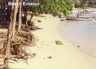 Coastal
segments where marked erosion have been identified are in the region of
Flic-en-Flac (West), Le Morne (South-West), Riambel (South), Pointe d'Esny
(South-East), Cap-Malheureux and Grand Bay (North). It has been observed
that the coastline is receding by almost 1 m per year in some places. Sea
level rise will enhance the erosion problems of already threatened regions
and increase the vulnerability of other areas.
Coastal Infrastructure
Coast roads representing 5% of the sea front are
located mainly in the southern and eastern regions. It has been estimated
that about 12 km of main coast road and 25 km of secondary coast road could
be at risk with a rise in sea level.
More than 1000 houses will be totally under threat
and 100 units partly. Based on the occupancy rate of 4.7 per unit, it is
estimated that almost 6000 people (0.6% of the population) would be affected.
Coral reefs
Coral reefs are also susceptible to climate change
as this would lead to higher water temperatures and rising sea level. In
many parts of the world reefs have undergone episodes of bleaching. During
the recent El-Nino episode when a temperature increase of 2 °C above
the mean was observed in the water surrounding the Seychelles, widespread
coral bleaching occurred.
In Mauritius, coral bleaching has occasionally been
observed and has been attributed mostly to pollution.
Coastal Wetlands
Coastal wetlands are mostly found at elevations below
the highest tide of the year and above mean sea level. They usually oscillate
and move in response to changes in sediment supply and relative sea-level
rise. The rate at which wetlands migrate is still unknown.
In Mauritius, some wetlands have been backfilled
for development purposes and this has caused flooding in other places.
Agriculture
Sugar production, the main agricultural activity,
is a key element of the Mauritian economy and is expected to continue for
the forthcoming decades. The sugar industry together with other agricultural
activities have a strong socio-economic bearing and need to be assessed
for their vulnerability.
The impacts of climate change on agriculture were
analysed using the following assumptions:
-
elevated levels of CO2/other GHGs on the
physiology of crop plants and weeds
-
changes in climate parameters (temperature, precipitation
and solar radiation) on plants and animals, and
-
sea level rise on agricultural land
Direct effects of elevated
CO2 and other greenhouse gases
The major effects of increased CO2 levels
on productivity are through photosynthesis and respiration, as well as
on water use, crop development and product quality. In most cases higher
increases in productivity can be expected with the C3 plants compared
to C4 plants (e.g., sugar cane). Total production of dry matter
will increase, but not necessarily as sugar because of lower partitioning
into sucrose. Sugar beet producers will benefit more than cane sugar producers.
Weeds, mostly C3 plants, will grow more rapidly and
hence compete more severely with sugar cane with possible negative effects
on productivity.
Changes in the crop development and phenology can
potentially cause shortening or lengthening of the crop cycle and may lead
to decreases or increases in productivity. Structural changes especially
in the carbohydrate status may affect the nutritional value, taste, storage
quality and commercial value of some fruits and vegetables. Post-harvest
losses may be higher in the case of flowers while the lower nitrogen content
of fodder will mean reduced protein levels and hence diminished nutritional
value for livestock.
Increases in atmospheric CO2 will lower
crop water requirements by reducing transpiration per unit leaf area; its
benefit cannot be quantified. Biological nitrogen fixation may increase
or decrease and will result in different inputs of fertilizer.
Changes in climate parameters
Global warming is likely to lead to the following
changes:
-
The productivity zones of some crops will change from
the lowland areas to regions of higher altitudes.
-
Sugar cane cultivation will become more profitable in
the super humid zone and will compete with other crops and forestry.
-
Vegetable crops cultivated in the highlands, and needing
a cold climate for bulking might disappear being no longer productive.
-
The duration of some crops will shorten with concurrent
reductions in yield.
-
Cropping calendars, flowering and productivity of some
fruits and vegetables will be affected.
-
Pastures that are actually in the low-lying dry areas
may support fewer animals as a result of lower grazing potential.
-
Livestock will be under higher stress and poultry production
may decrease because of higher mortality rates.
Temperature increases will change and extend the geographical
range of some insect pests. The number of generations per year of some
insects may increase with earlier establishment of the pest coinciding
with vulnerable stages of crops and resulting in severe losses. Interspecific
interactions between pests, their predators and parasites may change with
integrated pest control becoming less effective.
Most agricultural diseases are expected to reach
more severe levels under warmer conditions. Deseases caused by fungi and
bacteria will become more recurrent in case warmer temperatures are accompanied
with higher precipitation. The geographical range of the diseases also
may change thus affecting susceptible cultivars grown in these areas.
The expected changes in rainfall amount, pattern
and distribution make it difficult to assess its effect on agriculture.
Relatively small changes in amount and seasonal distribution can have large
effects on crop productivity in tropical areas. The magnitude and frequency
of drought periods and heat stress could be of direct concern. There is
a distinct possibility that sugarcane land in the sub-humid zone will become
economically non-productive as a result of higher rates of evapotranspiration.
Irrigation might have to be adopted in or extended to these areas.
Important indirect effects of climate change on agriculture
come from concurrent effects on other physical systems. The most important
is water resources and groundwater recharge.
The various impacts of climate change on crop and
animal production could have higher order effects on income, employment,
food production and exports. Production costs will change and may rise
in terms of altered management requirements such as irrigation adoption
or extension and reduction of pest and disease damages. Profitability at
the national and farm level will change among other things because of changes
in the production potential, in the costs of inputs and prices of outputs.
The effect of climate change on a regional and international basis will
also impede on profitability. This will in turn affect employment and the
society.
Sea level rise
Agriculture and mangroves occupy about 45% of the
coastal frontage. Agricultural activities will be under risk as a consequence
of saline drift from sea-spray that will contribute to land degradation
through salinisation of neighbouring soil. Mangroves are expected to retreat
inland.
Concluding Remarks
The magnitude of change in the different climatic
parameters will determine the vulnerability of our agricultural production
and how many adaptive measures need be taken to maintain productivity.
GCM outputs for Mauritius indicate that the increase in temperature will
affect most of our agriculture. It is certain that all crops will not be
affected to the same extent and that the same crop will respond differently
in various regions. This will require different adaptive measures. Government
may have to react to the effects of climate change at the regional and
international levels even if effects at national level were negligible.
Water Resources
The fresh water supply of Mauritius comes from rivers,
man-made lakes, natural lakes, and ground water basins. The 2100 mm mean
annual rainfall is largely sufficient to replenish these water resources
systems that have a total available storage capacity of the order of 460
Mm3. Both surface and underground water are utilized for domestic,
industrial and agricultural purposes. There is still potential to exploit
additional ground water to cater for increasing demands. Average per capita
water consumption was about 190 l day-1 in 1995.
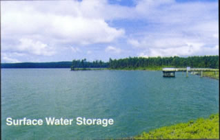 Water
quality is closely tied up with the management of the coastal system. Water intrusion,
pesticide use, agrochemicals and haphazard disposal of waste may cause toxic chemicals
to penetrate into the water resource systems. Used water from sugar mills is discharged
into the rivers and ends up in the lagoon. Government is well aware of potential
water pollution and has embarked on an aggressive program including monitoring
of surface, ground and lagoon water with special attention paid to effluents from
industrial dying and washing.
Mauritius depends for 60% of its needs on underground
water for domestic, industrial and agricultural purposes. Boreholes that
are situated near the coast will be at risk due to salt-water intrusion.
Fisheries
Fisheries include coastal, banks and deep-sea fishing
and aquaculture. Coastal fishery is the main source of fresh fish for the
local markets. The annual production of fresh fish has stabilized at around
1600 t, peaking in the month of March. In August and September the catch
usually decreases due to unfavourable weather.
Fish Aggregating Devices (FAD) installed by the Albion
Fisheries Research Centre (AFRC) at various sites 1.5 to 12 km off the
coast of Mauritius also play an important role in the supply of fresh pelagic
fish to the local markets.
Fish obtained from sea banks represents 30% of the
total fish consumption. The main banks exploited are the Nazareth and Saya
de Malha along the Mauritius - Seychelles ridge and in the region of the
Chagos, St Brandon and Albatros islands. The total annual catch from the
banks was about 4400 t in 1995. Fishing on banks is mainly conducted when
the weather is favourable.
The tuna-fishing zone lies between latitudes 4°N
to 11°S and longitudes 50°E to 84°E and the regions around
the Chagos are very productive. About 2800 t of tuna were landed in 1995:
the main species being skipjack (67%), yellow fins (21%) and big-eye (10%).
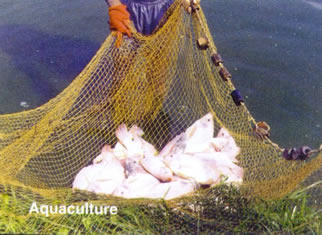 Marine
aquaculture focuses on shrimp farming and fresh aquaculture involves the
fish "berri-rouge" and crayfish.
Climate change impacts on fish stocks and distribution
can be assessed through variations in water properties or indirectly through
fishing activities dependent on weather. Fish habitat and behaviour are
directly related to climate.
Increased sea surface
temperature
A rise in sea surface temperature causes:
-
decrease in the amount of oxygen.
-
increase in growth of aquatic plants
-
increase in metabolic rates of organisms
Though General Circulation Models (GCMs) outputs only
provide for expected changes in air temperature, multiple-regression analysis
used in the development of models has indicated a significant rise in sea
surface temperature also.
The decrease in dissolved oxygen will affect fish
population through:
· increased
mortality of adults and juveniles
· reduction
in growth
· lower
survival rates of eggs and larvae
Nutrients
Nitrates, phosphates and silicates are important
nutrients. Their concentrations are higher in deep water and replenishment
of upper layers comes through vertical diffusion, overturning and upwelling.
Changes in wind regime and ocean circulation are expected to impact on
the intensities and location of upwelling areas and hence on the distribution
of nutrients leading to changes in fish population and migration behaviour.
Changes in climatic conditions
on fish yield
More frequent changes in the wind and thermal stratification
regime will be detrimental to the fish population since larval survival
will be affected. Higher frequencies of weather extremes are expected to
affect fishing operations.
Tuna fishery
Tuna is a migratory species and the choice of the
route is strongly determined by sea surface temperature. The 28°C isotherm
has been found to coincide with concentrations of tuna.
The vertical distribution of biomass and fish depends
on the depth of the thermocline. A deeper thermocline necessitates more
investments for exploitation.
The effects of El Nino
It is predicted that El Nino occurrence will become
more frequent, intense and of longer duration with climate change. It has
been observed that whenever a major El Nino occurs, warming also takes
place in the other major ocean basins. Studies have also shown that El
Nino will induce changes in ocean currents, upwelling and upper ocean heat
content thus affecting size and location of fish stocks.
Health
Health is defined by the WHO as "… a state of complete
physical, mental and social well-being and not merely the absence of disease
or infirmity." Climate has been found to act on human health through its
effect on ecosystems, water resources, food species, disease agents and
vectors. Available data show some correlation between number of malaria
cases and heavy rainfall episodes unless appropriate precautionary measures
are taken. Marked outbreaks of flu are also noted during some months of
the year as a result of fluctuating temperatures. It is therefore important
to consider human health and well-being under a climate-change scenario.
Climate change is expected to have a negative impact
on human health in Mauritius. A 2°C increase in the average temperature
when added to the already sultry conditions prevailing during summer in
the capital city and the other coastal areas will be detrimental to the
health of elderly persons, small children and chronic invalids. Furthermore,
a combination of such temperatures with high values of relative humidity
is bound to be catastrophic to human health.
Urbanization is relatively dense, as most people
prefer individual dwellings to apartment buildings. Large areas are being
covered by concrete structures with few parks and gardens being accommodated.
Residential buildings have been erected to serve more as shelters from
strong cyclonic winds than as efficient energy-consuming units. During
summer these get heated up by solar radiation and emit the stored heat
at night thus considerably increasing indoor temperatures.
Air conditioning facilities are becoming an important
household item and as the lower income group will not be able to afford
such facilities, excess heat will become a major health problem. A nation
that cannot rest and recover will not be productive and is most likely
to suffer from cumulative distress.
Land use change and forestry
Land use change
Deforestation has had a very strong influence on
land as a resource and climate changes will in turn compound the damage.
These impacts will be discussed in terms of the effects of increased CO2
level and changes in climate parameters.
Increased CO2
level
Elevated CO2 level will alter the composition
of plants and will result in organic matter with a high carbon:nitrogen
and carbon:phosphorus ratio. Such organic matter has a low rate of decomposition
thereby slowing nutrient recycling. The activity of decomposer micro-organisms
will be reduced by the poorer quality of the plant material while fungi
may thrive as a result of the higher carbon content of the litter. Changes
in the flora and fauna of the soil may affect its physical and chemical
properties in the long-term and may necessitate changes in land use.
Climate parameters
Different rainfall patterns could affect distribution,
tolerance, evolution and survival of animal and plant species resulting
in a change in ecosystems. Rainfall of very high intensity may become more
frequent. The resulting soil erosion may be severe thereby altering the
uses made of land in certain areas. Leaching may increase on sloping land.
Lower productivities may demand changes in land use and in extreme cases
land may be simply abandoned.
Forestry
Increased CO2
level
The highest risk on existing natural forests may
result from some species responding more positively to the temperature
increase, CO2 fertilization, changing rainfall and solar radiation
patterns. The devastating effects of extreme climate events such as tropical
cyclones could render regeneration more difficult. They will result in
changes that could alter the biodiversity in the long-term. Plantation
forests may be affected in their productivity.
Climate parameters
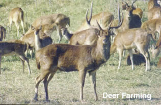 Higher
evapotranspiration demands of the forests used for grazing may cause this
land to become less productive and result in lower carrying capacities.
ADAPTIVE MEASURES
Coastal resources
Of the three categories of responses required to
protect human life and property, as recommended by the IPCC, the protection
and accommodation options would be more appropriate as Mauritius is too
small in size for the retreat or abandonment option.
Protection options
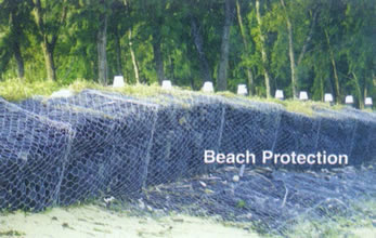
Hard structures to protect beaches are at times the
only viable options. However studies should be conducted to identify the
best orientation of these structures. The use of Gabion structures should
be extended and improved on the basis of past experience.
 Soft
solutions such as vegetative cover should be adopted where appropriate. Walkways
should be constructed to avoid further degradation of the already scarce vegetation
of the beach.
Beach nourishment, a more popular form of erosion
control, should be adopted. Future coastal protection should include beach
restoration and maintenance as well as cyclone wave protection by dunes.
Accommodation options
The set back distance should be increased to beyond
the present 15 m high-water mark. Steps should be taken to ensure that
the removal of sand is completely banned as from the year 2001.
The existing passes through the reefs should not
be enlarged and new passes should be avoided completely.
Agriculture, land use
change and forestry
Agriculture
Agricultural systems have always adapted to changes
and the magnitude and nature of the impacts will determine the degree of
adjustment. It is certain that adaptation will depend on the degree of
adoption of new technologies and management rules but will be constrained
by economic and political factors. Expected adjustments will come through
changes in land use, management and infrastructure. However, because of
all the uncertainties linked with climate change it is very difficult to
recommend specific options.
Changes in land use
The implementation of changes in land use does not
seem to be a possible adaptive measure since land is a limited resource.
A change in crop type also does not appear to be practicable. The cultivation
of more drought resistant crop cultivars could be an interesting adaptive
strategy for regions where soil moisture will become the limiting factor.
A change in the harvest date can also be envisaged so as to make more efficient
use of environmental resources.
Changes in management
and infrastructure
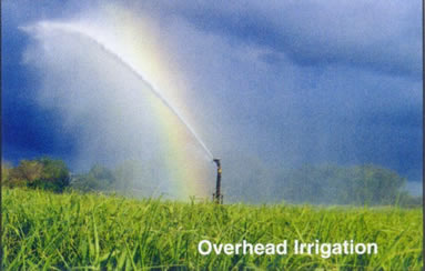 As
crop water requirements will increase under warmer conditions and with
a possibility of poorer rainfall distributions, irrigation facilities will
have to be extended.
Fertilizer use will change and increased amounts
may be needed to counteract the effect of soil erosion and leaching. Farm
infrastructure and practices may require changes to mitigate the effects
of climate change.
Forestry
The best option appears to be closer monitoring for
the prevention of further degradation. More adapted species can be introduced
for exploitation in the plantation forests. The ecosystems need to be more
closely monitored for prompt action in case the balance of species is affected.
Tree plantation along river banks and motorways are to be envisaged.
Water resources
Adaptation options to maintain and ensure an adequate
supply and quality of water are :
-
encouraging the use of "gray" water for secondary household
use
-
constructing rain catchment backup tanks
-
monitoring groud-water sources in the outer islands
-
increasing storage capacity.
Concluding Remarks
The magnitude of change in the different climatic
parameters will determine the vulnerability of the different sectors and
the extent to which adaptive measures need to be adopted to limit their
effects. Decision-makers may have to react promptly to counteract the possible
impacts of climate change.
 Coastal
segments where marked erosion have been identified are in the region of
Flic-en-Flac (West), Le Morne (South-West), Riambel (South), Pointe d'Esny
(South-East), Cap-Malheureux and Grand Bay (North). It has been observed
that the coastline is receding by almost 1 m per year in some places. Sea
level rise will enhance the erosion problems of already threatened regions
and increase the vulnerability of other areas.
 Water
quality is closely tied up with the management of the coastal system. Water intrusion,
pesticide use, agrochemicals and haphazard disposal of waste may cause toxic chemicals
to penetrate into the water resource systems. Used water from sugar mills is discharged
into the rivers and ends up in the lagoon. Government is well aware of potential
water pollution and has embarked on an aggressive program including monitoring
of surface, ground and lagoon water with special attention paid to effluents from
industrial dying and washing.
 Marine
aquaculture focuses on shrimp farming and fresh aquaculture involves the
fish "berri-rouge" and crayfish.
 Higher
evapotranspiration demands of the forests used for grazing may cause this
land to become less productive and result in lower carrying capacities.
 Soft
solutions such as vegetative cover should be adopted where appropriate. Walkways
should be constructed to avoid further degradation of the already scarce vegetation
of the beach.
 As
crop water requirements will increase under warmer conditions and with
a possibility of poorer rainfall distributions, irrigation facilities will
have to be extended.